Hargraves Lookout in the Blue Mountains

Scenic view of a vast, green valley with dense forest, distant mountains, and a partly cloudy sky. Sunlight highlights patches of the landscape, creating contrast and depth.

Hargraves Lookout stands as one of the Blue Mountains’ most rewarding yet lesser-known viewing points, offering sweeping 360-degree panoramas across the Megalong Valley and Kanimbla Valley without the overwhelming crowds that characterise more famous lookouts. Located at the southern tip of Shipley Plateau near Blackheath, this historic vantage point provides visitors with spectacular views of rural farmland, dramatic escarpments, and the Narrow Neck Plateau stretching toward Katoomba. Recently refurbished with wheelchair-accessible facilities and multiple viewing platforms, Hargraves Lookout delivers an authentic Blue Mountains experience combined with modern amenities that make it accessible to all visitors.

Hargraves Lookout Overview

Hargraves Lookout presents a peaceful alternative to the busier tourist spots around Katoomba and Leura, facing westward over the pastoral landscapes of the Megalong and Kanimbla valleys. This remote and isolated lookout provides unique perspectives rarely seen from other Blue Mountains vantage points.

The lookout offers several distinctive features:

  • Historic significance: Opened to the public in 1915, Hargraves Lookout holds the distinction of being one of the first purpose-built tourist spots in the Blue Mountains, named after Blackheath pioneer William Hargraves (1839-1925), who developed an extensive network of walking tracks in the Medlow area.
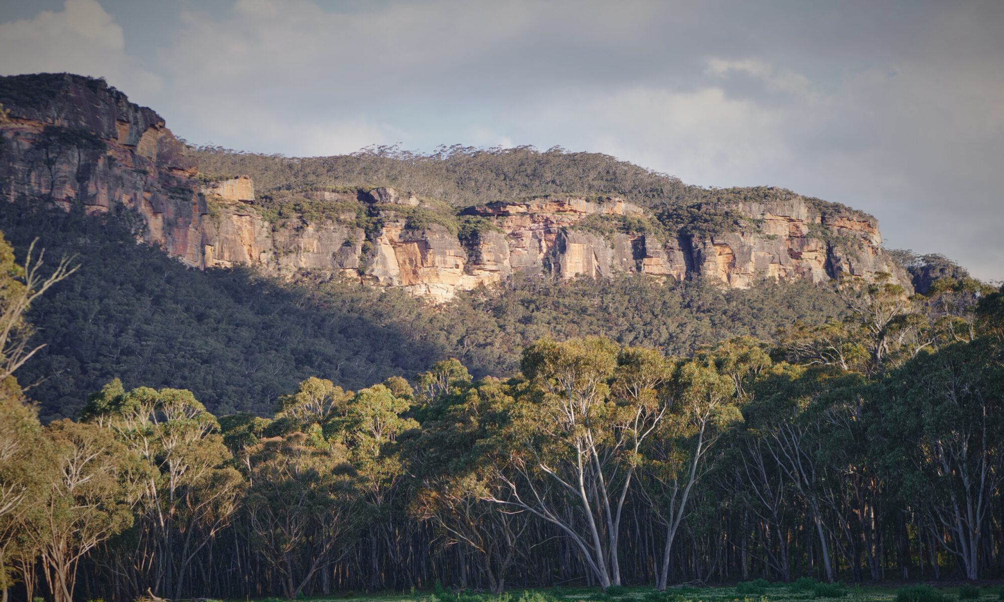
  • Valley views: Sweeping panoramas extend across the bucolic twin valleys of Megalong and Kanimbla, showcasing farmland, forest, and rolling green valleys framed by mountain ranges.
  • Landmark sightings: On clear days, visitors can spot the historic Hydro Majestic Hotel perched on the clifftop at Medlow Bath, the escarpment toward Katoomba, and views extending as far as Oberon.
  • Multiple viewpoints: The lookout area consists of several viewing platforms at different elevations, each offering unique perspectives of the surrounding landscape.

The lookout’s position at approximately 1,000 metres elevation provides unobstructed views that change dramatically with weather and lighting conditions, making it particularly popular with photographers seeking dramatic landscape shots.

Location and Accessibility

Hargraves Lookout sits at the southernmost point of Shipley Plateau in Blackheath, west of the Great Western Highway. The lookout is easily reached by car via a scenic drive through charming local apple orchards.

Getting There:

  • From Blackheath town centre: Follow Shipley Road from Station Street, continuing approximately 7.5 kilometres to the end of the road where the lookout is located.
  • Road conditions: The first several kilometres are sealed, with the final 2-3 kilometres on an unsealed gravel road. The road has been recently upgraded and is in very good condition, suitable for all vehicles in dry weather conditions. A 4WD is not essential.
  • Journey time: Approximately 15-20 minutes drive from Blackheath town centre.
  • Parking: Spacious parking area immediately adjacent to the main lookout, including designated disabled parking spaces. Parking is free.

Public Transport Considerations:

While Blackheath is accessible via train from Sydney (approximately 2.5 hours from Central Station), there is no direct public transport to Hargraves Lookout. Visitors relying on public transport would need to arrange a taxi or rideshare from Blackheath Station, or undertake a 6-kilometre walk from town (approximately 1.5-2 hours, with some steep sections).

Recent Upgrades:

In 2021, Blue Mountains City Council completed a $500,000 refurbishment of Hargraves Lookout, transforming it into a fully accessible destination:

  • New viewing platforms with accessible ramps
  • Improved paving and fencing throughout
  • Wheelchair-accessible toilet facilities
  • Enhanced picnic areas with shelters
  • Better defined pathways and safety barriers

Hargraves Lookout Features

The lookout area provides multiple vantage points and walking opportunities, each offering different perspectives on the surrounding valleys and mountains.

Main Viewing Platform:

The primary viewing platform sits just steps from the parking area, offering immediate access to spectacular valley views:

  • Accessibility: Fully wheelchair accessible with no steps required, making it ideal for visitors with mobility considerations.
  • Vista highlights: Sweeping views across the Megalong Valley floor, with farmland creating patchwork patterns below. The Narrow Neck Plateau is clearly visible, extending toward Katoomba, while the Kanimbla Valley spreads to the right.
  • Interpretive elements: Historic stone picnic cabanas and remnants of early tourist infrastructure add character to the viewing area.
  • Facilities: Picnic tables and shelters available near the platform, with open fire pits for those planning extended stays.

Additional Viewing Platforms:

Beyond the main platform, two smaller viewing areas provide different angles on the landscape:

  • Lower platform: The smallest and lowest viewpoint offers a more intimate perspective, positioned closer to the edge with dramatic drop-offs creating an exhilarating viewing experience.
  • Side platform: Alternative vantage point showcasing different sections of the valleys and providing varied photographic compositions.
  • Safety features: All platforms feature sturdy railings and fencing, though those with height concerns should exercise appropriate caution at the cliff edges.

Panorama Point Walking Trail:

An adventurous short walking trail extends from the smallest viewing platform at Hargraves Lookout to Panorama Point, offering even more expansive views:

  • Trail characteristics: Follows a narrow ridge with somewhat challenging terrain. The path isn’t always well-defined, adding an element of adventure for those comfortable with basic bushwalking.
  • Distance and duration: Approximately 1 kilometre return, taking 20-30 minutes for most walkers.
  • Trail features: Passes the Hargraves Trig Station along the way, providing interesting historic elements.
  • Views: Panorama Point delivers unique perspectives different from the main lookout, with far-stretching valley views rewarding those who make the trek.
  • Difficulty: Rated as moderately challenging due to narrow ridge sections and less defined path. Suitable footwear is essential.

Best Times to Visit

Hargraves Lookout shines during specific times of day and seasons, with lighting and atmospheric conditions dramatically affecting the viewing experience.

Optimal Viewing Times:

  • Sunrise: The western-facing orientation means sunrise visitors enjoy soft morning light gradually illuminating the valleys as the sun rises behind them. Early morning often delivers the clearest air with minimal haze.
  • Sunset: The lookout’s westward perspective makes it exceptional for sunset viewing, with the sun descending directly into the valleys ahead. The escarpment explodes with colour as golden hour progresses, making this the most popular time for photographers.
  • Golden hour: The hour before sunset provides the most dramatic lighting, with warm tones enhancing the red and orange hues in the sandstone cliffs and creating long shadows across the valleys.

Seasonal Considerations:

  • Spring (September-November): Wildflowers bloom in the surrounding scrub, adding splashes of colour to the landscape. Flannel flowers are particularly beautiful during this season. Weather generally stable with comfortable temperatures.
  • Summer (December-February): Longer days provide more flexibility for timing visits, though afternoon haze can reduce distant visibility. Early morning or late afternoon visits avoid the midday heat.
  • Autumn (March-May): Crisp, clear days deliver exceptional visibility, often allowing views to extend to Oberon and beyond. Comfortable temperatures make extended stays enjoyable.
  • Winter (June-August): Clear winter days provide spectacular visibility, though strong winds can make the exposed lookout quite cold. Morning frost occasionally creates ethereal scenes. Sunset occurs earlier, requiring arrival by mid-afternoon.

Weather and Crowd Patterns:

  • Weekday visits: Significantly quieter than weekends, often providing complete solitude to enjoy the views without interruption.
  • Weekend considerations: While busier than weekdays, Hargraves Lookout remains far less crowded than Echo Point or other major Katoomba attractions.
  • Special conditions: Rainbows frequently appear during showery weather, creating stunning photographic opportunities across the valleys.

Nearby Attractions and Trails

The Hargraves Lookout area connects to several other exceptional viewing points and attractions, making it ideal for combining multiple destinations in a single visit.

Mount Blackheath Lookout:

Located just 10 10-minute drive from Hargraves Lookout via Mount Blackheath Road:

  • Elevation: At 1,076 metres, this lookout sits atop Mount Blackheath, providing dramatic western views over the Kanimbla Valley.
  • Hang-gliding launch site: Features a purpose-built ramp where hang-gliders and paragliders launch when conditions are suitable. On the right day, gliders can soar all the way to Bathurst.
  • Facilities: Picnic area, toilet facilities, and parking are available at the summit.
  • Access: Also managed by Blue Mountains City Council, meaning dogs are allowed on leads (unlike NSW National Parks lookouts).

Blackheath Lookouts Circuit:

Hargraves Lookout forms part of an excellent driving route taking in Blackheath’s cluster of spectacular viewpoints:

  • Eastern lookouts: Govetts Leap (featuring the tallest single-drop waterfall in the park), Evans Lookout, Anvil Rock, and Perrys Lookdown offer stunning Grose Valley views.
  • Circuit option: Visitors can create a full-day itinerary visiting multiple lookouts, each offering different perspectives on the Blue Mountains landscape.
  • Photography opportunities: The circuit provides varied subjects from waterfalls to valley vistas, cliff faces to wilderness panoramas.

Walking Tracks:

  • Grand Canyon Track: Accessible from Evans Lookout, this stunning loop walk descends into a narrow canyon featuring temperate rainforest, waterfalls, and unique rock formations.
  • Cliff Top Track: Connects Evans Lookout with Govetts Leap, providing clifftop walking with continuous valley views.
  • Blue Gum Forest: The challenging descent from Perrys Lookdown leads to this beautiful valley forest, though it requires serious fitness and experience.

Other Nearby Attractions:

  • Megalong Valley attractions: The valley visible from the lookout contains horse riding facilities, wineries, and the historic Six Foot Track trailhead.
  • Blackheath village: Charming town centre features cafes, antique shops, galleries, and the Blue Mountains Heritage Centre with excellent displays and information.

Visitor Tips

Successful visits to Hargraves Lookout benefit from practical preparation and awareness of conditions.

Access and Road Conditions:

  • Unsealed road caution: While generally in good condition, the gravel section can become rough after heavy rain. Drive cautiously and watch for potholes.
  • Tour bus limitations: The narrow, unsealed road and limited turning space at the lookout mean tour buses don’t visit Hargraves, contributing to its peaceful atmosphere.
  • Vehicle suitability: Standard cars handle the road well in dry conditions, though ground clearance helps on rougher sections.

Facilities and Amenities:

  • Toilets: Clean, wheelchair-accessible toilet facilities are available at the parking area.
  • Picnic facilities: Sheltered picnic tables, BBQ areas, and historic stone cabanas provide comfortable spots for extended stays.
  • Drinking water: Not available at the lookout. Bring sufficient water, particularly during warmer months.
  • Mobile coverage: Generally reliable at the lookout, though may be patchy in some spots.

Photography Considerations:

  • Equipment recommendations: Wide-angle lens captures the expansive valley views, while telephoto lens isolates distant features like the Hydro Majestic Hotel or specific valley sections.
  • Tripod usage: Essential for sunset photography as light fades. The exposed position can be windy, so ensure a stable setup.
  • Optimal conditions: Clear days after rain often provide the best visibility, with atmospheric haze minimised.
  • Polarising filter: Helps reduce haze and enhance the blue tones in distant mountains and sky.

Safety and Comfort:

  • Weather preparation: The exposed clifftop location experiences strong winds. Bring warm layers even on seemingly mild days, particularly for sunset visits.
  • Sun protection: Limited shade available at viewing platforms. Hats, sunscreen, and sunglasses are essential during daytime visits.
  • Footwear: If planning to walk to Panorama Point, sturdy shoes with good grip are necessary. The main platforms are accessible in regular footwear.
  • Edge awareness: While all platforms have safety barriers, supervise children closely near cliff edges.

Stargazing Opportunities:

Hargraves Lookout’s remote location and minimal light pollution make it exceptional for astronomy:

  • Dark sky benefits: Zero light pollution provides clear views of the Milky Way and countless stars invisible in urban areas.
  • Western horizon: The unobstructed western view allows observation of celestial objects as they set.
  • Access considerations: The unsealed road requires careful night driving. Bring torches and ensure someone knows your plans if visiting after dark.

Dog-Friendly Note:

As a Blue Mountains City Council-managed site (not NSW National Parks), Hargraves Lookout permits dogs on leads, making it ideal for visitors wanting to include pets in their Blue Mountains adventure.

Hargraves Lookout delivers spectacular Blue Mountains scenery combined with peaceful solitude, historic ambiance, and modern accessibility. Whether you’re seeking dramatic sunset photography, a quiet picnic spot away from crowds, or simply want to experience a different perspective on the Blue Mountains’ iconic valleys, this beautifully refurbished lookout deserves a prominent place on your itinerary. The scenic drive through apple orchards, the multiple viewing platforms, and the optional walk to Panorama Point create a complete experience that showcases the best of the Blackheath area.

Cahill’s Lookout in Blue Mountains

A fenced lookout platform sits on a rocky cliff edge, overlooking a vast expanse of forest and rugged, orange-brown mountains under a cloudy sky.

Cahill’s Lookout stands as one of Katoomba’s most rewarding yet underrated vantage points, offering sweeping panoramas of the Megalong Valley without the overwhelming crowds that characterise more famous Blue Mountains lookouts. Located at the western end of Cliff Drive, this scenic spot provides visitors with dramatic views of Boars Head Rock, the expansive Narrow Neck Plateau, and the rugged wilderness stretching toward the Kanangra Wilderness. Named after John Joseph Cahill, the NSW Premier who commissioned the Sydney Opera House and the Cahill Expressway in the 1950s, this lookout delivers an authentic Blue Mountains experience with multiple viewing platforms and a peaceful atmosphere.

Cahill’s Lookout Overview

The Cahill Walk lookout presents a refreshing alternative to the busier Echo Point and Three Sisters viewing areas, facing westward over the Megalong Valley rather than the more commonly photographed Jamison Valley. This unique orientation provides visitors with stunning perspectives of the Narrow Neck Peninsula, the dramatic plateau that divides the two major valleys of the Blue Mountains.

From the viewing platforms, you can experience:

  • Valley views: Panoramic vistas extending across the Megalong Valley floor to distant ranges beyond, with the Six Foot Track visible snaking through the forest below after descending Nellies Glen.
  • Boars Head Rock: The distinctive ironstone-fretted formation provides a striking focal point and popular subject for photographers.
  • Wilderness perspectives: Views stretching toward the southern wilderness of the Greater Blue Mountains World Heritage Area, including glimpses of Mount Solitary on clear days.

The lookout’s elevated position at approximately 960 metres above sea level delivers unobstructed views that extend for kilometres. Unlike the more touristed locations, Cahill’s Lookout maintains a tranquil character that allows visitors to genuinely connect with the landscape rather than jostling for position among crowds.

Location and Accessibility

The Cahill lookout, Katoomba, is situated at 258-276 Cliff Drive, approximately 3.5 kilometres from Katoomba Station and easily reached by car, bus, or on foot from the Scenic World area.

Getting There:

  • By car: Follow Cliff Drive from either Scenic World (heading west) or Valley Road and Narrow Neck Road (from the Great Western Highway). Dedicated paid parking is available at the trailhead, though spaces fill quickly during peak periods. Parking fees typically run around $10 per hour.
  • By public transport: Nearest bus stops on Narrow Neck Road and Acacia Street. Bus routes 686 and 687 service the area regularly from Katoomba Station.
  • On foot: Pleasant 30-minute walk along Cliff Drive from Scenic World, passing several other viewing points along the way.

The Walk:

The paved 300-metre walking track from the car park to the main viewing platform takes approximately 15 minutes return and is suitable for most fitness levels. Visitors should note that the final section includes steps that make wheelchair and pram access challenging beyond the Boars Head Lookout viewpoint.

Cahill’s Lookout Features

According to the NSW National Parks and Wildlife Service, the Cahill’s Lookout walking trail offers multiple viewing opportunities along its short but rewarding length, with each platform providing different perspectives of the valley and surrounding features.

Boars Head Lookout

Approximately halfway along the paved track, Boars Head Lookout provides your first stunning vista and an excellent view of the distinctive Boars Head Rock formation. This unique ironstone outcrop resembles its namesake when viewed from this angle, creating one of the most photographed features along the walk.

Key features include:

  • Accessibility: The platform remains accessible to wheelchairs and prams, making it an ideal stopping point for families with young children or visitors with mobility considerations.
  • Rock climbing views: The Boars Head Rock serves as a popular climbing destination, and on clear days, you might spot climbers tackling routes on this impressive formation.
  • Valley perspectives: Views northeast toward Megalong Head and Nellies Glen, where the Six Foot Track begins its descent into the valley.

Main Viewing Platform

The central viewing platform at Cahill Walk lookout, Sydney, NSW, represents the highlight of the short walk, delivering panoramic vistas that justify the journey. From this elevated position, the Megalong Valley spreads out below in spectacular fashion, with the Narrow Neck Plateau forming a dramatic spine between the Megalong and Jamison valleys.

What makes this platform special:

  • Golden hour magic: The western orientation makes it particularly special during late afternoon and sunset, when golden light illuminates the valley floor and casts long shadows across the ridges.
  • Pastoral history: Closer inspection reveals farmland on the valley floor, remnants of the area’s pastoral history stretching back to the 1800s.
  • Wilderness views: Unobstructed views extend to the Kanangra Walls in clear conditions, providing a sense of the vast wilderness that characterises the Greater Blue Mountains region.
  • Space to spread out: Unlike compact viewing areas at busier lookouts, this platform offers space to truly absorb the scenery without feeling rushed.

Smaller Viewing Platforms

Two additional platforms branch off from the main viewing area, each offering slightly different perspectives worth exploring:

  • Northern platform: Provides excellent views of Megalong Head and the beginning of Nellies Glen, perfect for understanding the geography of the Six Foot Track’s starting point.
  • Southern platform: Delivers the best vantage point for photographing Boars Head Rock with Mount Solitary as a dramatic backdrop.
  • Thrilling positioning: Both platforms feature safety railings but offer that exhilarating sense of being suspended above the cliff edge, with sheer drops creating a memorable viewing experience.

Taking time to visit all three platforms rewards you with a comprehensive understanding of the valley’s geography and the dramatic landscape that makes the Blue Mountains such a celebrated destination.

Best Times to Visit

The Cahill lookout Blue Mountains shines during golden hour, making sunrise and sunset the optimal times for both photography and peaceful contemplation.

Sunrise Benefits:

  • Minimal crowds and a peaceful atmosphere for quiet reflection
  • Soft morning light gradually illuminates the valley as the sun rises behind you
  • Clearer conditions with less atmospheric haze affecting distant views
  • Opportunities to watch the valley wake up with morning mist

Sunset Advantages:

  • Western orientation provides front-row seats to the sun’s descent behind the ranges
  • Warm afternoon light enhances red and orange tones in sandstone cliffs
  • Constantly evolving colours create dynamic photographic opportunities
  • Arriving 30-45 minutes early allows time to explore all platforms

Seasonal Considerations:

  • Spring: Wildflowers bloom in the surrounding heath, adding colour to the landscape
  • Summer: Longer days but more heat and afternoon haze
  • Autumn: Crisp, clear days with excellent visibility and comfortable temperatures
  • Winter: Occasional fog fills the valley, creating ethereal scenes as mist gradually lifts

Weekday mornings generally offer the quietest experiences, while weekend afternoons can become busier but remain far less crowded than Echo Point or the Three Sisters.

Nearby Attractions and Trails

The Cahill Expressway lookout area serves as an excellent starting point for exploring other nearby attractions along Cliff Drive.

Adjacent Lookouts:

  • Peckmans Plateau Lookout: Just 300 metres from the car park, offering another quick viewing opportunity worth including in your visit.
  • Narrow Neck Lookout: A short drive further west, the Narrow Neck Lookout provides stunning views of the Narrow Neck Peninsula itself and access to the Narrow Neck Plateau trail, a popular mountain biking and walking route extending approximately 9 kilometres beyond a locked gate.

Walking Trails:

  • Devils Hole Loop: Begins nearby, providing a longer hiking option for those wanting to explore further through eucalypt forest and past additional viewpoints.
  • Narrow Neck Plateau Trail: A 9.4-kilometre track (one way) offering spectacular views into surrounding valleys, suitable for experienced walkers and mountain bikers.

Popular Attractions Within Easy Distance:

  • Scenic World: Approximately 2 kilometres east, featuring the famous Scenic Railway, Skyway, and Cableway attractions
  • Three Sisters and Echo Point: About 3 kilometres distant, making it easy to combine Cahill’s Lookout with the region’s most iconic sights in a single day
  • Katoomba Falls: Located along Cliff Drive between Cahill’s Lookout and Scenic World

Visitor Tips

Successful visits to Cahill’s Lookout benefit from practical preparation across several key areas.

Footwear and Clothing:

  • Wear comfortable walking shoes with a good grip, as the paved path can become slippery after rain
  • Bring an extra layer, even on warm days, as wind can be significant at the exposed clifftop location
  • Pack sunscreen and hats during the summer months, as shelter from the sun is limited
  • Consider a waterproof jacket, as the Blue Mountains’ weather changes rapidly

Timing and Crowds:

  • Visit early morning on weekdays (before 9:00 AM) to avoid crowds and secure parking easily
  • Late afternoon arrivals (after 4:00 PM) also offer quieter experiences
  • Small parking area fills quickly during peak times, particularly weekends and public holidays
  • Arrive at least 30-45 minutes before sunset if planning an evening visit

Weather Considerations:

  • Check conditions before setting out, as fog or low cloud can obscure valley views entirely
  • The exposed lookout offers limited shelter from rain or harsh sun
  • Visibility can be severely reduced during low cloud, making it worth rescheduling your visit
  • Wind at the clifftop can be strong, particularly during afternoon hours

Practical Essentials:

  • Bring coins or card for paid parking ($10 per hour typically)
  • Pack a picnic to enjoy at viewing platforms or nearby picnic tables
  • Carry out all rubbish, as bins are limited at the site
  • Water bottles recommended, especially during warmer months

Photography Tips:

  • Bring a wide-angle lens to capture expansive valley views
  • A telephoto lens helps isolate distant features like Mount Solitary or rock climbers on Boar’s Head
  • Polarising filters are particularly effective for reducing haze and enhancing blue tones in distant ranges
  • Western light creates ideal conditions for dramatic landscape photography during golden hour

Cahill’s Lookout delivers everything visitors seek in a Blue Mountains viewing point: spectacular scenery, manageable accessibility, and a peaceful atmosphere, without the overwhelming crowds that can diminish the experience at more famous locations. Whether you’re a first-time visitor or a Blue Mountains regular, this gem deserves a prominent spot on your itinerary.

Six Foot Track: Blue Mountains Adventure Guide

A person walks across a long, narrow suspension bridge high above a river in a forested, mountainous area under a clear sky.

The Six Foot Track stands as one of Australia’s most celebrated walking trails, stretching 44 kilometres from Katoomba in the Blue Mountains to the legendary Jenolan Caves. Originally constructed in the 1880s to provide horse and cart access to the caves, this historic route now attracts thousands of hikers and trail runners each year who come to experience its dramatic landscapes, pristine wilderness, and challenging terrain.

The track’s name refers to its original width specification, though nature has since reclaimed much of the path. Today’s adventurers follow in the footsteps of early explorers, descending from the Blue Mountains plateau through eucalypt forests, crossing river valleys, and climbing ridges that showcase some of New South Wales’ most spectacular backcountry scenery.

Track Sections and Highlights

The Blue Mountains Six Foot Track divides naturally into three distinct sections, each offering unique challenges and rewards. The full journey typically takes experienced hikers 2-3 days to complete, with elevation changes totalling over 1,200 metres of ascent and descent. The track passes through the Blue Mountains National Park and Kanangra-Boyd National Park, providing opportunities to spot native wildlife, including wallabies, wombats, and countless bird species.

Katoomba to Megalong Valley

The first 14 kilometres begin at the Explorers Tree near Katoomba’s outskirts, descending sharply into the Megalong Valley. This section presents several key features:

  • The descent: Approximately 600 metres through dense eucalypt forest, with the Nellies Glen track junction offering spectacular valley views. The steep gradient can be tough on knees, particularly after rain when the track becomes slippery.
  • Valley floor: The terrain flattens dramatically as you cross pastoral land with the Narrow Neck plateau forming an impressive backdrop. This contrast from mountain forest to open farmland creates one of the track’s most memorable transitions.
  • Time and distance: This section typically takes 4-5 hours and ends at the Megalong Valley camping area, where many hikers spend their first night before continuing deeper into the wilderness.

Megalong Valley to Coxs River

Spanning roughly 15 kilometres, this middle section showcases the track’s most diverse landscapes. You’ll cross farmland before entering forest and descending to the Coxs River, the trail’s lowest point at approximately 400 metres elevation. The Bowtells Swing Bridge provides a memorable river crossing, swaying gently as you traverse above the clear mountain water.

This section includes the Alum Creek campsite and ends at the Coxs River camping area, where most overnight hikers choose to stop. The combination of valley walking and gradual climbs makes this a moderate 5-6 hour section that allows time to enjoy the changing scenery and perhaps cool off in the river during warmer months.

Coxs River to Black Range

The final 15 kilometres present the track’s greatest challenge, climbing 700 metres from the Coxs River to the Black Range before descending to Jenolan Caves. The ascent through forest to Mini Mini Saddle tests even fit walkers, though the effort rewards you with panoramic views across the wilderness.

After cresting the range, the track descends through woodland to emerge at the Jenolan Caves Reserve, where the Grand Arch provides a spectacular finishing point. Allow 6-7 hours for this demanding section, starting early to ensure you complete the climb before the afternoon heat builds.

Key Crossings and Bridges

Water crossings define much of the Six Foot Track experience, with conditions varying dramatically between seasons:

  • Bowtells Swing Bridge: The most significant crossing at Coxs River features this narrow suspension bridge that adds adventure to your journey. While generally stable, the bridge’s movement can unsettle nervous crossers. During flood conditions, this crossing becomes impassable, and walkers must wait for water levels to recede.
  • Six Foot Track Guyver Bridge: Located near the Megalong Valley section, this more substantial structure remains suitable for all weather conditions. Unlike Bowtells, it provides a stable crossing year-round.
  • Creek crossings: Several smaller creeks along the route may require rock-hopping or wading during wet periods, making waterproof boots recommended regardless of season.

Accommodation and Camping

Overnight walkers have several accommodation options along the Six Foot Track. The NSW National Parks and Wildlife Service maintains two official camping areas at Megalong Valley and Coxs River, both offering basic facilities including pit toilets and water access (which must be treated before drinking). Sites operate on a first-come basis and fill quickly during peak periods, particularly Easter and long weekends. Camping permits are required and can be obtained through the NPWS website before your departure.

Additional camping at Alum Creek offers a quieter alternative between Megalong Valley and Coxs River, though facilities are more basic. All campers should register their trip and obtain necessary permits before setting out.

Six Foot Track Eco Lodge

For those preferring more comfort, the Six Foot Track Eco Lodge at Megalong Valley provides a luxurious alternative:

  • Comfortable beds and hot showers after a long day’s hiking
  • Meals included, eliminating the need to carry cooking equipment
  • Strategic location at the day-one endpoint allows lighter packs on the opening descent
  • Accepts both guided tour groups and independent bookings

Private accommodation also exists at both trail ends in Katoomba and Jenolan Caves, allowing flexible itinerary planning.

Six Foot Track Events

The Six Foot Track Marathon ranks among Australia’s premier trail running events, attracting over 900 participants annually since its 1984 inception. Despite its name, the Six Foot Track race covers the full 45-kilometre course, with runners tackling the challenging terrain in a single day. Elite competitors finish in under four hours, while the seven-hour cutoff accommodates recreational runners and fast hikers.

Held annually in March, the event transforms the usually peaceful track into a competitive arena. The race starts at 6:00 AM from Katoomba, with participants streaming down the Megalong descent before the day’s heat builds. Multiple aid stations provide water and nutrition, while volunteers from the Blue Mountains Rural Fire Service stationed at key points ensure runner safety. The event operates as a not-for-profit initiative, with all proceeds donated to the rural fire service.

Registration typically opens in November and operates through a lottery system due to high demand, with entry fees around $240. Race entry includes transport back to Katoomba from the finish line, timing chips, and a finishers’ bag. The event also offers a relay option for teams wanting to share the challenge across different sections of the track.

Guided Tours and Support

Six Foot Track Life’s An Adventure operates the most established guided walking tours along the route, offering fully supported multi-day treks. Their packages include accommodation at the eco lodge, meals, pack transfers, and experienced guides who share insights into the region’s natural and cultural history. This option suits walkers wanting to focus on the experience without logistical concerns.

Other operators provide variations, including self-guided packages with pack transfers, allowing independent hiking with lighter loads. These services transport your overnight gear between accommodation points while you carry only day-pack essentials. For ultra-light enthusiasts and experienced bushwalkers, the track is entirely manageable independently, with water sources along the route (treatment essential) and well-marked trails requiring only basic map-reading skills.

Preparation and Safety Tips

Successful Six Foot Track completion requires proper preparation across several key areas:

Essential Gear

  • Sturdy hiking boots (worn-in, not new) to prevent blisters on the long descent
  • Three-season tent for camping, capable of handling mountain weather
  • Water purification tablets or a filter, as all natural water sources require treatment
  • First aid kit including blister treatment and pain relief
  • Navigation tools, including a map, a compass, and GPS backup
  • Sufficient food for your planned journey plus one extra day
  • Warm and waterproof layers, regardless of the forecast, as the weather can change rapidly

Safety Considerations

  • Register your walk with the NPWS and leave detailed plans with friends or family
  • Carry at least 3 litres of water capacity, as sources can be scarce between sections
  • Mobile coverage is nonexistent through most sections, making emergency communication impossible without a satellite device
  • Personal Locator Beacons can be hired for free at the Blue Mountains Heritage Centre in Blackheath
  • Start early each day to avoid afternoon heat and ensure adequate daylight for navigation
  • Attempt river crossings during morning hours when water levels are typically lowest
  • The track’s remote nature means help can take hours to arrive, so self-sufficiency is crucial

Best Times to Visit

Spring and autumn offer ideal conditions with mild temperatures and lower rainfall probability. Summer brings heat that makes the exposed sections challenging, while winter can deliver snow to the Black Range. Check fire danger ratings before departure, as total fire bans may close the track during extreme conditions.